Croichead Chaisleán an Chomair: sábháilteacht níos fearr, oidhreacht threisithe
Le Seandálaí BIÉ Bernice Kelly
Bhí tionchar ag trasbhealaí abhann riamh anall ar an gcaoi ar mhair daoine, ar an taisteal a rinne siad, agus ar an gcaoi ar chosain siad a gcuid críocha. Leis na céadta blianta, san áit a dtagann aibhneacha le chéile – tairseacha nádúrtha tríd an taobh tíre – mheall siad idir lonnaíocht agus aird straitéiseach. Ní haon chomhtharlú é go bhfuil baile Chaisleán an Chomair i gContae Chill Chainnigh ainmnithe i ndiaidh áit den sórt sin. Is ón gcaisleán Angla-Normannach a bhí mar cheann faire ag cumar na Deighne agus a fo-aibhneacha, a tháinig an t-ainm Caisleán an Chomair – an caisleán ag an gcumar nó an áit a dtagann an abhainn le chéile.
Sa lá atá inniu ann, tugtar cuairteoirí a bhíonn ag déanamh anoir ar Chaisleán an Chomair trasna na Dighne ar dhroichead galánta cúig áirse ón 18ú haois, agus a chló dronnach ag éirí go mall ina shuaitheantas aitheanta áitiúil. Tugtar an ‘Droichead Mór’ nó ‘Droichead Bhaile Átha Cliath’ air, agus tá níos mó i gceist leis ná díreach trasbhealach praiticiúil; is léiriú seandálaíochta é ag a bhfuil cúlra spéisiúil, agus ar déanmhas cosanta nó struchtúr atá faoi chosaint é anois.
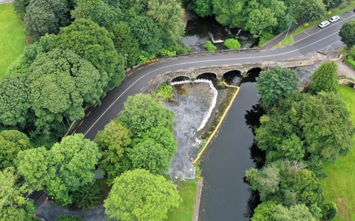
Image 1: Suíomh Dhroichead Chaisleán an Chomair, Co. Chill Chainnigh (Oifig Bóithre Náisiúnta Chomhairle Contae Chill Dara)
The Ritheann an Deighean ó dheas, ag deighilt an bhaile ó Theach Chaisleán an Chomair agus a diméin mar a bhí tráth den saol, a thóg Sir Christopher Wandesforde (Fear Ionaid na hÉireann níos déanaí). Ag an bpointe seo, tagann dhá fho-abhainn isteach sa scéal: Clohogue a thagann aniar agus Brokagh a thagann anoir. In ainneoin tagairtí chomh fada siar leis an 13ú haois do ‘castle of Combre (caisleán Chomair)’, ní hann d’aon taifead soiléir ar dhroichead ag an am sin. Ina ionad sin, is dóigh gur thug áth níos túisce ná sin bealach trasna na habhann. Go deimhin, ní thaispeántar aon droichead anseo ar léarscáil an Down Survey ó 1655-8. Fós féin, faoi 1714, léiríonn léarscáil Herman Moll d’Éirinn trasbhealach bóthair ag Caisleán an Chomair, rud a thugann le fios gur tógadh droichead sna blianta roimhe sin – á spreagadh gan dabht ag éilimh mhéadaithe thionscal guail agus oibreacha iarrainn an réigiúin, a d’fhorbair muintir Wandesforde, a bhí ag brath ar ghluaiseacht sheasta oibrithe agus earraí.
Níor mhair an droichead a bhí ann roimhe sin. Is fada an lá an abhainn seo luaite le tuilte, meastar go ndéantar cur síos leis an ainm Gaeilge, an Deighean, ar an sruth tapa uisce anseo, ag tabhairt le fios go bhféadfadh an luas damáiste a dhéanamh. Deimhníodh an cháil sin a bhí ar an abhainn ar an 2 Deireadh Fómhair 1763, nuair a thug tuile tubaisteach léi an droichead cloiche a bhí i gCaisleán an Chomair. Bhí an tubaiste forleathan, scriosadh droichid feadh na Feoire agus a fo-aibhneacha. Sna cuntais stairiúla déantar trácht ar dhaoine a fuair bás de réir mar a d’ardaigh an t-uisce san oíche, tuile a scrios Droichead Eoin agus Droichead an Ghraoinigh i gCill Chainnigh agus a bhí mar shiocair le droichead Binéid agus droichead Bhaile Mhic Andáin ‘a tharraingt anuas’, agus ‘dhá áirse de dhroichead Inis Tíog a bhriseadh ina bpíosaí’.
Mar fhreagra air sin, thug Parlaimint na hÉireann cistí don atógáil, agus tugadh an obair don Chorparáid Loingseoireachta Intíre, a rinne coimisiúnú ar dhearaí ón ailtire George Smith. I gCaisleán an Chomair, níorbh fhada gur tosaíodh ar an obair ar dhroichead nua a thógáil, rud a léirigh an phráinn a bhain leis an tslí seo a chur ar ais, rud a bhí riachtanach do na mianaigh ghuail.
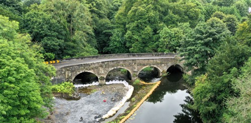
Image 2: Droichead Chaisleán an Chomair: an t-ardú suas an abhainn (BIÉ)
Tá an struchtúr a cruthaíodh dá bharr ar cheann de na saintréithe lena n-aithnítear an baile. Tá sé déanta as eibhear, agus tá cúig áirse theascánacha mhaorga sa droichead. Is iad na cuasáin mhaisiúla atá socraithe isteach sna hascaillí stua os cionn earrainní uillinneacha na gnéithe is suntasaí de – mionsonraí lena dtugtar idir rithim agus mhíneadas don struchtúr. Is macalla d’fhasaigh chlasaiceacha iad na gnéithe sin, go háirithe Ponte di Tiberio in Rimini, i dtuaisceart na hIodáile, agus léiríonn siad an tionchar a bhí ag an ailtireacht Phallaidiach, a bhí faiseanta ag an am. Bhain Smith leas as móitífeanna den chineál céanna ina dhearaí le haghaidh Dhroichead an Ghraoinigh i gCathair Chill Chainnigh agus ag an droichead ag Gráig na Manach, rud a d’fhág go bhfuil Droichead Chaisleán an Chomair ina chuid de ghrúpa níos leithne de dhroichid lena mbaineann tábhacht náisiúnta. Tugann pictiúr comhaimseartha leis an ealaíontóir clúiteach as Cill Chainnigh John Comerford léiriú ar an droichead sna blianta tosaigh, rud a thugann le fios an mórtas a bhí as an bpíosa bonneagair suaithinseach ach nua-aimseartha seo.
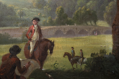
Image 3: Íomhá as pictiúr ola le John Comerford (Bailiúchán de chuid Mhuintir Wandesforde roimhe seo)
Bhí an droichead féin ina ábhar conspóide in 1798, le linn an Éirí Amach. Bhí sé i gcroílár coimhlinte idir fórsaí na Corónach agus na hÉireannaigh Aontaithe i ndiaidh dóibh treabhadh ó thuaidh tar éis Chath Chnoc Fhiodh na gCaor. I dteannta mianadóirí áitiúla, rinne na ceannaircí iarracht an trasbhealach a ghabháil, iad ag brú cairteacha féir agus tuí lasta ina threo. Cé gur scriosadh an baile go forleathan agus gur maraíodh daoine ar an dá thaobh, tháinig an droichead féin slán.
Le himeacht na gcéadta blianta, tháinig sé slán ó thuilte eile agus ón mbrú seasta a bhain le gnáthúsáid ó lá go lá. Mar sin féin, ní raibh deic caol an droichid – nach raibh beartaithe riamh do thrácht na linne seo – oiriúnach d’éilimh bhóthar cruógach an N78. D’fhág an méadú ar an trácht le blianta beaga anuas, na cuairteoirí a thugann cuairt ar Pháirc Thaiscéalaíochta Chaisleán an Chomair ina measc, go raibh gá le trasbhealach ní ba shábháilte.
Chun dul i ngleic leis sin, choimisiúnaigh Comhairle Contae Chill Chainnigh, le maoiniú ó Bhonneagar Iompair Éireann, droichead nua do choisithe, suas an abhainn ina sheasamh as féin ón droichead cloiche.
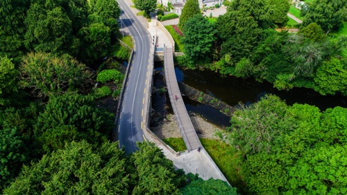
Image 4: Radharc ón aer ar an droichead stairiúil agus ar an droichead nua do choisithe (Oifig Bóithre Náisiúnta Chomhairle Contae Chill Dara)
Dhear RPS Consulting Engineers an droichead i gcomhar le Powell-Williams Architects, agus thóg Kenny Civils and Plant Ltd é, agus is léiriú ar chuir chuige innealtóireachta nua-aimseartha é an struchtúr agus a shuíomh stairiúil á chomhlánú ag an am céanna. Tá an droichead cruach dhá réise, le taca ó phiara sa lár suite ar oileáinín beag, mar a bheadh macasamhail chomhaimseartha dá leathbhádóir ón 18ú haois.
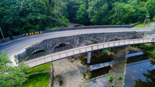
Image 5: An droichead coisithe nua, Droichead na Mianadóirí, leis an droichead stairiúil ar gcúl (Oifig Bóithre Náisiúnta Chomhairle Contae Chill Dara)
Thug scrúduithe seandálaíochta a rinneadh sular tógadh an droichead rianta fíorspéisiúil de ghníomhaíocht níos túisce ná sin ag an láthair le fios. Tugadh pílí adhmaid a bhí suite istigh sa phábháil cloiche ar ghrinneall na habhann faoi deara faoi bhun agus suas ón droichead stairiúil. Measadh le dátú radacarbóin gur tháinig ceann acu ó thús an 16ú haois, rud a thiocfadh leis an tuairim go raibh pointe trasnaithe ann cheana féin. D’fhéadfadh baint a bheith ag spruadair smionagair a fuarthas gar don teannta thiar le foirgnimh a scriosadh le linn chíor thuathail 1798, agus léiríonn sraodbhalla cloiche ar an taobh thoir oibreacha athailínithe bóthair níos túisce, tráth ar feabhsaíodh an bealach isteach chuig an droichead agus tráth ar cuireadh síneadh ar cheann dá chuid áirsí.
In 2022, beagnach 260 bliain tar éis an ‘Droichead Mór’ a thógáil, osclaíodh an trasbhealach nua do choisithe don phobal. D’oir a ainm nua go deas dó, ‘Droichead na Mianadóirí’, agus tugtar ómós dóibh siúd ar mhúnlaigh a saothar an baile agus a d’fhág go raibh gá le ceangail den sórt sin. Ní hamháin go dtugann sé bealach trasna sábháilte ach is áit é ina bhfuil radharc maith ar an droichead stairiúil agus ar an gcora níos faide suas an abhainn.

Image 6: An droichead stairiúil agus an droichead comhaimseartha taobh le taobh (BIÉ)
In 2025, treisíodh an láthair arís nuair a suiteáladh painéal léirithe ann, áit a raibh deis ag cuairteoirí sos a ghlacadh agus a machnamh a dhéanamh ar stair fhada fhillte na trasbhealaí abhann seo

Image 7: Painéal léirithe ag Droichead Chaisleán an Chomair (BIÉ)
Rinne John Cronin and Associates agus Mizen Archaeology scrúduithe seandálaíochta, agus rinne Rob Goodbody tuilleadh taighde ar an droichead. Is féidir súil a chaitheamh ar an tuarascáil theicniúil trí Bhailiúcháin Oidhreachta Digití BIÉ ag https://doi.org/10.7486/DRI.6t05hh253
Posted 16 April 2026